


Baksiganj Upazila (jamalpur district) with an area of 204.30 sq km, is bounded by India on the north, Islampiu upazila on the south, sreebardi upazila on the east and Dewanganj upazila on the west. Main rivers are Dasani, Jirjira and old Brahmaputra noted depressions are Singijan and Kuaka Bells. The Gyro Hills are on the north east part of the upazila.
Baksiganj (Town) The area of the Baksiganj town is 3.86 sq km. It has a population of 8573; male 50.97%, female 49.03%; population density is 2220 per sq km. Literacy rate among the town people is 25.9%.
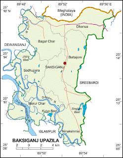
Administration Baksiganj thana was turned into an upazila in 1982. The upazila consists of 7 union parish ads, 25 mousses and 203 villages.
Historical events During the war of liberation the Pakistan army established a military camp at Kamalpur, in the northern sector. From the point of view of war strategy this camp was so important that its fall meant to lose control over the whole Jamalpur-Dhaka region. The freedom fighters attacked Kamalpur many times. On 31 July 1971 the freedom fighters attacked Kamalpur under the command of Major Moinul Hussein Chowdhury, Battalion Commanding. open day 4 December 1971.
Officer of the 1st East Bengal Regiment of Sector 11. This time final victory was not achieved but the casualty in the Pakistan army was huge. In this battle 35 freedom fighters including Captain Salahuddin Momtaz, Ahaduzzaman and Abdul Kalam Azad were killed. On 14 November 1971 Abu Taher lost one of his legs by explosive.
Marks of War of Liberation Mass grave 7, Playground of Baksiganj High School, Kamalpur Health Centre, Kamalpur Bazaar, Battajor, Dhanua Baksiganj Cattle Hat, Baxiganj Bazaar.
Population 2,14903; male 50.80%, female 49.20%; Muslim 98.08%, Hindu 1.25%, Christian 0.44%, and others 0.23%.
Religious institutions Mosque 287, temple 1.
Literacy and educational institutions Average literacy 22.4%; male 22.4%, female 44.8%. Educational institutions- college 5, secondary school 38, madras a 46, government primary school 49, non-government primary school 60.
Cultural organizations' Rural club 27, cinema hall 2, literary society 6, women's organization 1, play ground 22
Main occupations Agriculture 40.46%, fishing 1.28%, agricultural laborer 26.24%, wage laborer 2.95%, commerce 12.92%, service 3.08% and others 13.07%.
Land use Total cultivable land 14885.88 hectares, fallow land 2747.88 hectares; single crop 9.36%, double crop 56.22% and treble crop land 34.42%.
Land control Among the peasants 21.21% are landless, 30.07% marginal, 31.12% small, 14.52% intermediate and 3.08% rich.
Value of land The market value of the land of the first grade is 7500 Taka per 0.01 hectare.
Main crops Paddy, jute, sugar cane, mustard seed, wheat, sweet potato, turmeric, onion, garlic, cabbage, cauliflower, baronial, pulse and vegetables.
Extinct or nearly extinct crops Linseed, sesame, kaun, corn and peanut.
Main fruits Banana, black berry, papaya, pine apple and water melon.
Fisheries, dairies, poultries Cattle breeding center 2, poultry farm 16, hatchery 3.
Communication facilities Roads: puce road 36 km, semi puce 19 km, mud road 106 km.
Traditional transport Palanquin, horse carriage and bullock cart. These means of transport are either extinct or nearly extinct.
Cottage industries Loom 1700, handicrafts 36, blacksmiths 98, potteries 9, bamboo and cane works 355, wood workers 132, jute and cotton works 16.
Hats, bazaars and fairs Hats and bazaars are 5, most noted hat is Niamey Mia Hat.
Main exports Jute, paddy, cotton, mustard seed, onion, garlic and turmeric.
NGO activities Operationally important NGOs are BRAC, ASA, GRAMEEN, BANK, CARE, Unnayan Sang-ha and Ibiza.
Health centers' Upazila health complex 1, family planning center 7, satellite clinic 3.
Sarwar Zaman Ratan


0 comments:
Post a Comment